


DS Altimeter + Recorder


Perihal DS Altimeter + Recorder
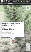
DS Altimeter is an animated real-time elevation meter.
An altitude recorder is also provided so that you can record and obtain altitude profiles for your favorite journeys to the highlands, the lowlands and everything in-between!
Configuration options allow you to choose your source for elevation data including GPS Satellite based altitude or location based elevation from the United States Geologic Survey and NASA's Shuttle Radar Topography Mission.
USGS data is available only for customers in the contiguous United States, Canada and Mexico.
GPS satellite altitude, normally reported as elevation above the WGS84 Geoid, is corrected to altitude above sea level with the World Geoid Height Model.
Devices equipped with a barometer sensor can also obtain pressure altitude, easily converted to true altitude by selecting a QNH value from the app's list of your local airports.
Raw barometric altitude data and corrected GPS altitude do not require an internet connection.
<b>Altimetry mapping and bathymetry (lake and sea depths) are also included with DS Altimeter. Tap anywhere on a map to get the altitude or water depth at that location.</b>
* Great for skiing, hiking, mountain climbing, boating, marine navigation and anytime you are curious about your elevation!
</br>
</br>
</br>
</br>
</br>
</br>
DS Altimeter + Recorder - Versi 4.13
(13-10-2016)

DS Altimeter + Recorder - Maklumat APK
Versi APK: 4.13Pakej: com.discipleskies.android.altimeterVersi Terkini DS Altimeter + Recorder


Aplikasi dalam kategori sama

Anda juga mungkin suka...


